Hurricane Ian could become Category 4 storm. Naples out of NHC cone

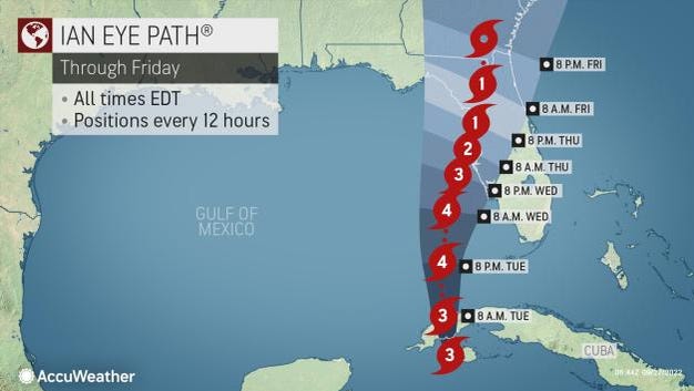
Hurricane Ian made landfall in western Cuba early Tuesday as a powerful Category 3 storm and is now moving toward Florida.
Maximum sustained winds were at 125 mph when the eyewall moved ashore just southwest of La Coloma, Cuba, at 4:30 am, according to the National Hurricane Center.
Ian weakened slightly during the latest advisory as it continues its path toward Florida. The forecast calls for Ian to become a weak Category 4 storm, with winds reaching 130 mph, within the next 12 hours.
Cone of uncertainty: See the latest graphic from the NHC
Satellite images: See latest satellite image from NOAA, for a clearer picture of the storm’s size
Hurricane-force winds are expected in the hurricane warning area in west-central Florida beginning Wednesday morning, with tropical storm conditions expected by late today.
Heavy rainfall will increase across the Florida Keys and south Florida today, spreading into central and northern Florida tonight and Wednesday, and into the Southeast US by Thursday and Friday, likely causing flash, urban, and small stream flooding.
Considerable flooding is expected across central Florida into southern Georgia and coastal South Carolina, with widespread, prolonged moderate to major river flooding expected across central Florida.
Ian has maximum sustained winds of 115 mph, according to an advisory issued at 11 am by the National Hurricane Center.
The storm is forecast to re-strengthen later today through Wednesday as it moves toward Florida. Ian is forecast to approach the west coast of Florida as an extremely dangerous major hurricane.
Hurricane-force winds extend 35 miles from center. Tropical-storm-force winds extend 140 miles from center.
Ian is located 278 miles southwest of Naples, and is moving north at 10 mph.
Hurricane warnings and watches are in effect across much of Florida’s West Coast. Tropical storm watches and warnings are in effect along Florida’s East Coast and a portion of Florida’s Big Bend/Panhandle area.
On the forecast track, the center of Ian is expected to move over the southeastern Gulf of Mexico in a couple of hours, pass west of the Florida Keys later today, and approach the west coast of Florida within the hurricane warning area on Wednesday and Wednesday night.
More coverage as Hurricane Ian approaches Florida
► Three scenarios, with divergent levels of destruction to Florida | WeatherTiger
► ‘Floridians up and down Gulf Coast’ warned as Hurricane Ian strengthens, could reach Category 4
► ‘Impacts are going to be far and wide’: DeSantis urges entire Gulf Coast to prepare for Ian
► Hurricane Ian’s forecast calls for ‘rapid intensification.’ What does that mean?
Re-strengthening is expected later today through Wednesday. Ian is forecast to approach the west coast of Florida as an extremely dangerous major hurricane.
A major hurricane is one where maximum sustained winds are at least 111 mph, which makes it a Category 3 storm. A Category 4 storm has maximum sustained winds of 130 to 156 mph.
A Category 4 storm could bring catastrophic damage to an area.
Life-threatening storm surge looks increasingly likely along much of the Florida West Coast where a storm surge warning is in effect, with the highest risk from Fort Myers to the Tampa Bay region, the Hurricane Center said.
The National Weather Service warned storm surge flooding could be greater than 9 feet in the Tampa and St. Petersburg areas.
Potential impacts from storm surge alone could bring “structural damage to buildings, with many washing away. Damage greatly compounded from considerable floating debris. Locations may be uninhabitable for an extended period.
“Near-shore escape routes and secondary roads (could be) washed out or severely flooded.”
Where is Hurricane Ian now?
Here is the latest data on Hurricane Ian pulled from the National Hurricane Center’s 11 am advisory.
- Location: 278 miles southwest of Naples
- maximum sustained winds: 115mph
- movements: north at 10mph
- Pressure: 963 MB (millibars)
- When next advisory will be released: 2 pm
Spaghetti models: Track Hurricane Ian
Watches and warnings issued ahead of Hurricane Ian
Helpful hurricane resources and links
Get your home ready: Here’s how to prepare your home for a hurricane, from well in advance to just before a storm’s arrival
Need to prepare for a hurricane? Here’s what you should have in a disaster supply kit
Hurricane preparedness list: If a storm is coming, here is what you need to do now
Video: Helpful tips for a hurricane survival kit
Hurricanes, typhoons, and cyclones: What’s an invest and why do they keep saying tropical cyclone?
Officials encourage residents to assemble a hurricane kit early, storing enough supplies to last at least three days. Doing so ensures there are adequate supplies available on store shelves and prevents a rush — and shortages — that regularly occur when a storm is imminent.
USAT-Florida Network has removed the paywall for hurricane-related content for residents within the path of Ian to help keep everyone safe and informed during this emergency. Please consider subscribing.
See similar https://www.naplesnews.com/story/weather/hurricane/2022/09/27/hurricane-ian-naples-florida-impact-spaghetti-models-forecast-path-tracker/69518758007/
The post Hurricane Ian could become Category 4 storm. Naples out of NHC cone first appeared on Daily Florida Press.
Comments
Post a Comment